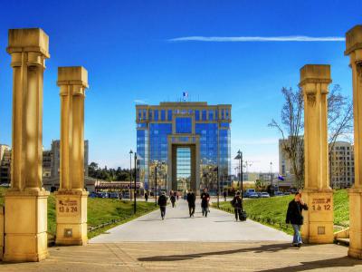
Antigone, Montpellier
Antigone is a distinctive neighborhood located east of Montpellier's historic city center, renowned for its striking architectural style conceived by the Spanish architect Ricardo Bofill. Developed on the former grounds of the Joffre Barracks, of which only the citadel of Montpellier remains today, this 36-hectare district was envisioned as a gateway for the city’s eastward expansion.
The project, initiated in 1977 under the leadership of Mayor Georges Frêche, was one of the most ambitious urban developments in France at the time, capturing global attention. Bofill’s design draws heavily on neo-classical elements, utilizing oversized pediments, entablatures, and pilasters to create monumental structures that contrast starkly with the traditional architecture of Montpellier. The grandiose scale and symmetry of the buildings reflect a modern reinterpretation of classical motifs, giving the neighborhood a unique visual identity.
The layout of Antigone is structured along a central axis that runs from Montpellier’s old center to the banks of the river Lez, where it visually connects with the Languedoc-Roussillon Region Hotel (Hôtel de la Région Languedoc-Roussillon), another Bofill masterpiece. This axis, often referred to as the “Champs-Élysées of Montpellier,” forms a one-kilometer-long promenade lined with boulevards, plazas, and parks.
The buildings within Antigone serve a variety of functions, including low-income housing, public facilities, shops, schools, and sports and cultural venues, making it a vibrant, self-contained urban environment. The stylistic coherence of the neighborhood, from the grand squares to the detailed facades, exemplifies Bofill’s vision of a harmonious urban landscape, setting a new standard in contemporary urban planning in the late 20th century.
The Antigone project not only redefined the eastern expansion of Montpellier but also laid the groundwork for subsequent developments in the area, reinforcing its role as a pivotal landmark in the city’s modern architectural heritage.
Want to visit this sight? Check out these Self-Guided Walking Tours in Montpellier. Alternatively, you can download the mobile app "GPSmyCity: Walks in 1K+ Cities" from Apple App Store or Google Play Store. The app turns your mobile device to a personal tour guide and it works offline, so no data plan is needed when traveling abroad.
Antigone on Map
Sight Name: Antigone
Sight Location: Montpellier, France (See walking tours in Montpellier)
Sight Type: Attraction/Landmark
Sight Location: Montpellier, France (See walking tours in Montpellier)
Sight Type: Attraction/Landmark
Walking Tours in Montpellier, France
Create Your Own Walk in Montpellier
Creating your own self-guided walk in Montpellier is easy and fun. Choose the city attractions that you want to see and a walk route map will be created just for you. You can even set your hotel as the start point of the walk.
Montpellier Introduction Walking Tour
The trouble with living in a pleasant seaside town in the middle ages was pirates. This was especially true for the town of Maguelone on the south shore of present-day France. A settlement more inland was combined with Maguelone under the feudal dynasty of Guilhem in 985. They added a castle and walls and called it Montpellier.
Montpellier was an important trading center in the 12th century and... view more
Tour Duration: 2 Hour(s)
Travel Distance: 2.2 Km or 1.4 Miles
Montpellier was an important trading center in the 12th century and... view more
Tour Duration: 2 Hour(s)
Travel Distance: 2.2 Km or 1.4 Miles
Murals and Street Art Walk
For those unaware, sunny Montpellier is more than just a quick getaway with a beautiful blue sky, sunshine, Mediterranean vibes and southern architecture. In fact, Montpellier is one of the few cities in France where all forms of street art, from elaborate murals to little gems that a passersby might not even notice right away, are found in rich supply, practically on every side street.
The... view more
Tour Duration: 1 Hour(s)
Travel Distance: 0.8 Km or 0.5 Miles
The... view more
Tour Duration: 1 Hour(s)
Travel Distance: 0.8 Km or 0.5 Miles


