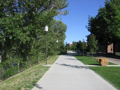
Boise River Greenbelt, Boise (must see)
The Boise River Greenbelt is a 29-mile linear park that winds along the north and south banks of the Boise River. Its path connects numerous city parks, wildlife areas, and neighborhoods, offering cyclists, runners, and walkers an immersive experience in Boise’s natural beauty.
Along the way, visitors encounter the “Ribbon of Jewels”, a chain of parks, along with fly fishing spots, native plant gardens, and nest boxes that support local birdlife. The route connects six major urban parks and features regular sightings of bald eagles in winter and peregrine falcons released by the nearby World Center for Birds of Prey.
Cultural institutions like the Discovery Center, Boise Art Museum, and the Idaho Historical Museum sit within easy reach of the trail, linked by walking bridges to Boise State University and the Great Basin Native Plant Garden. Just a short walk from downtown, visitors can explore the MK Nature Center, Kathryn Albertson Park, and even venture out to Esther Simplot Park, a popular spot for swimming and sunbathing. And if you’re craving more action, Boise Whitewater Park offers wave-shaping tech for urban kayaking and surfing.
For those looking to refuel or relax, the Greenbelt also serves up a slice of Boise’s culinary and creative scene. Sip a hemp milk cortado at Push and Pour, a skate-inspired café in Garden City, or sample regional wines at Telaya Wine Co.
Want to visit this sight? Check out these Self-Guided Walking Tours in Boise. Alternatively, you can download the mobile app "GPSmyCity: Walks in 1K+ Cities" from Apple App Store or Google Play Store. The app turns your mobile device to a personal tour guide and it works offline, so no data plan is needed when traveling abroad.
Download The GPSmyCity App
Boise River Greenbelt on Map


Sight Name: Boise River Greenbelt
Sight Location: Boise, USA (See walking tours in Boise)
Sight Type: Park/Outdoor
Sight Location: Boise, USA (See walking tours in Boise)
Sight Type: Park/Outdoor
Walking Tours in Boise, Idaho

Create Your Own Walk in Boise
Creating your own self-guided walk in Boise is easy and fun. Choose the city attractions that you want to see and a walk route map will be created just for you. You can even set your hotel as the start point of the walk.

Boise Introduction Walking Tour
For thousands of years the tree lined Boise River valley was home to the Shoshone people. They would meet here to trade with other tribes. The valley was congenial and the river full of salmon. It was a holy place for indigenous people.
The name "Boise" originated in the 1820s. The valley was thick with cottonwood trees. French Canadian trappers called it "La riviere boisee"... view more
Tour Duration: 2 Hour(s)
Travel Distance: 2.5 Km or 1.6 Miles
The name "Boise" originated in the 1820s. The valley was thick with cottonwood trees. French Canadian trappers called it "La riviere boisee"... view more
Tour Duration: 2 Hour(s)
Travel Distance: 2.5 Km or 1.6 Miles

Fort Street Historic District Walking Tour
The Fort Street Historic District roughly comprises 47 blocks, situated primarily within the 1867 plat of Boise City original townsite, and forms part of a larger area known locally as Boise's North End Preservation District. Upon its nomination, in 1982, for the National Register of Historic Places, the Fort Street district contained 318 buildings.
Over the years, this neighborhood has... view more
Tour Duration: 2 Hour(s)
Travel Distance: 1.8 Km or 1.1 Miles
Over the years, this neighborhood has... view more
Tour Duration: 2 Hour(s)
Travel Distance: 1.8 Km or 1.1 Miles