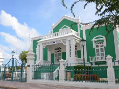
City Hall, Oranjestad
City Hall, also known as the Eloy Arends House, stands as a historical and functional landmark in Oranjestad. Constructed in 1922, the Eloy Arends House was initially designed as a residence for Dr. Jacobo Eloy Maria Arends and his fiancée, Maria Monica Laclé. The architect, Chibi Wever, infused South American Neo-Baroque influences into the design, creating a structure that harmonized with its surroundings.
The house incorporates sliding doors, allowing for adaptable use of interior spaces, showcasing a thoughtful and functional design. Over the years, the Eloy Arends House underwent various transformations, serving as a doctor's office, dentist's office, restaurant, and, controversially, as the headquarters of the People's Electoral Movement (MEP) in 1985.
In 1993, a fire caused significant damage to the building, leading to a period of neglect and homelessness. In 1997, the house underwent a meticulous restoration, transforming it into the official location for civil registration services.
The City Hall has become a popular destination for tourists to tie the knot, adding a romantic touch to its role as a hub for civil registrations.
Its historical charm and well-maintained aesthetics make it an attractive venue for couples seeking a unique and memorable wedding experience.
Want to visit this sight? Check out these Self-Guided Walking Tours in Oranjestad. Alternatively, you can download the mobile app "GPSmyCity: Walks in 1K+ Cities" from Apple App Store or Google Play Store. The app turns your mobile device to a personal tour guide and it works offline, so no data plan is needed when traveling abroad.
City Hall on Map


Sight Name: City Hall
Sight Location: Oranjestad, Aruba (See walking tours in Oranjestad)
Sight Type: Attraction/Landmark
Guide(s) Containing This Sight:
Sight Location: Oranjestad, Aruba (See walking tours in Oranjestad)
Sight Type: Attraction/Landmark
Guide(s) Containing This Sight:
Walking Tours in Oranjestad, Aruba
Create Your Own Walk in Oranjestad
Creating your own self-guided walk in Oranjestad is easy and fun. Choose the city attractions that you want to see and a walk route map will be created just for you. You can even set your hotel as the start point of the walk.
Oranjestad Introduction Walking Tour
Perched along the Dutch Caribbean Sea shore lies the picturesque capital of Aruba, Oranjestad. The locals still habitually refer to it as "Playa".
European settlers arrived on the island around 1754, establishing plantations along the coast. Urban development began around 1795-1796 as trade restrictions eased. Jewish settlers engaged in discreet smuggling from around 1796 chose Aruba... view more
Tour Duration: 2 Hour(s)
Travel Distance: 2.5 Km or 1.6 Miles

