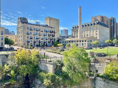


Mill Ruins Park / Water Works, Minneapolis
At the foot of the Stone Arch Bridge, where the Mississippi laps at its edges, Minneapolis’s history peeks out from the earth. Since the 1980s, archaeologists have unearthed remnants of old railway supports, milling equipment, and water-power infrastructure here. Rather than let these treasures disappear, they preserved them for curious explorers. Now, a walk along West River Parkway leads you to interpretive signs, wooden planks, and catwalks that guide you through the ruins and close to the bones of the city’s milling past.
Insider tip: Don’t miss Water Works, a lush three-acre oasis within Mill Ruins Park. It’s home to a two-story pavilion, outdoor plazas, and a patio where you can enjoy a bite at Owamni by the Sioux Chef, named Best New Restaurant in the country in 2022 by the James Beard Foundation. It’s a winning combo of history, greenspace, and award-winning modern Native American cuisine, all served up with some seriously unbeatable river views.
Insider tip: Don’t miss Water Works, a lush three-acre oasis within Mill Ruins Park. It’s home to a two-story pavilion, outdoor plazas, and a patio where you can enjoy a bite at Owamni by the Sioux Chef, named Best New Restaurant in the country in 2022 by the James Beard Foundation. It’s a winning combo of history, greenspace, and award-winning modern Native American cuisine, all served up with some seriously unbeatable river views.
Want to visit this sight? Check out these Self-Guided Walking Tours in Minneapolis. Alternatively, you can download the mobile app "GPSmyCity: Walks in 1K+ Cities" from Apple App Store or Google Play Store. The app turns your mobile device to a personal tour guide and it works offline, so no data plan is needed when traveling abroad.
Download The GPSmyCity App
Mill Ruins Park / Water Works on Map
Sight Name: Mill Ruins Park / Water Works
Sight Location: Minneapolis, USA (See walking tours in Minneapolis)
Sight Type: Park/Outdoor
Sight Location: Minneapolis, USA (See walking tours in Minneapolis)
Sight Type: Park/Outdoor
Walking Tours in Minneapolis, Minnesota

Create Your Own Walk in Minneapolis
Creating your own self-guided walk in Minneapolis is easy and fun. Choose the city attractions that you want to see and a walk route map will be created just for you. You can even set your hotel as the start point of the walk.

University of Minnesota - Minneapolis Campus Walking Tour
Founded in 1851, seven years before Minnesota became a state, the University of Minnesota is one of the largest educational institutions in the United States. The university campus in the “Twin Cities” of Minneapolis and Saint Paul, spread along the bank of the Mississippi River, is a sprawling hub renowned for its rich academic environment and vibrant life.
One of the central gathering... view more
Tour Duration: 2 Hour(s)
Travel Distance: 2.9 Km or 1.8 Miles
One of the central gathering... view more
Tour Duration: 2 Hour(s)
Travel Distance: 2.9 Km or 1.8 Miles

Saint Paul Introduction Walking Tour
Saint Paul is a fantastic example of a city that has grown through a diverse range of cultures. The location near the Mississippi River helped make what would later become the city a significant center of local trade. The Dakota Sioux tribe were among the earliest residents, and European settlement that included French-Canadian fur traders and Catholic missionaries occurred during the 1830s to... view more
Tour Duration: 2 Hour(s)
Travel Distance: 3.4 Km or 2.1 Miles
Tour Duration: 2 Hour(s)
Travel Distance: 3.4 Km or 2.1 Miles

Minneapolis Introduction Walking Tour
Minneapolis is a major city in Minnesota, straddling the Mississippi River. Together with neighboring Saint Paul, the state capital of Minnesota, it forms the metropolitan area collectively known as the "Twin Cities."
Before European settlement, the site of Minneapolis was inhabited by Dakota people. The settlement was founded along Saint Anthony Falls - the only natural waterfall on... view more
Tour Duration: 2 Hour(s)
Travel Distance: 4.2 Km or 2.6 Miles
Before European settlement, the site of Minneapolis was inhabited by Dakota people. The settlement was founded along Saint Anthony Falls - the only natural waterfall on... view more
Tour Duration: 2 Hour(s)
Travel Distance: 4.2 Km or 2.6 Miles

Historical Churches
The "City of Lakes”, Minneapolis, doesn't pride itself solely on the lakes. In fact, you will be amazed by how many churches, cathedrals, and other places of worship are found throughout the city. These sacred structures have played a significant role in the development of Minneapolis and continue to serve as pillars of faith and community. Let's take a look at some of the most... view more
Tour Duration: 1 Hour(s)
Travel Distance: 2.8 Km or 1.7 Miles
Tour Duration: 1 Hour(s)
Travel Distance: 2.8 Km or 1.7 Miles