Niagara Parkway, Niagara Falls
The Niagara Parkway, once known as Niagara Boulevard and historically as the Niagara Road, is a scenic route stretching along the Canadian side of the Niagara River in Ontario. Starting in Fort Erie in the south and running northward to Niagara-on-the-Lake, this picturesque drive traces the river's entire course, offering travelers a unique blend of natural beauty, historical landmarks, and tourist attractions.
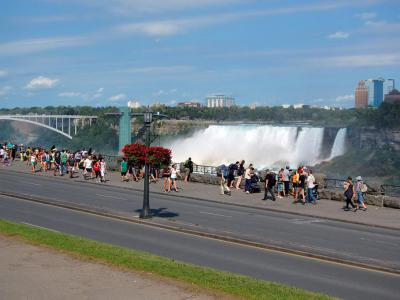
The southern segment of the parkway winds through several small villages before reaching the bustling tourist area of Niagara Falls. From there, the road continues past iconic sites such as the Whirlpool Rapids, the serene Butterfly Conservatory, and Brock’s Monument at Queenston Heights, ultimately ending near Fort George, on the outskirts of Niagara-on-the-Lake.
Initially, "Niagara Boulevard" only referred to the section between Fort Erie and Chippawa, but the full parkway took shape with construction beginning in 1908. Completed in 1931, it was designed as a scenic road lined with gardens and meticulously maintained green spaces. The stretch north of Table Rock in Niagara Falls even holds the designation of an Ontario Scenic Highway.
Its charm wasn’t lost on famous visitors—Sir Winston Churchill once famously described the Niagara Parkway as “the prettiest Sunday afternoon drive in the world.” With a mix of lush landscapes, cultural landmarks, and riverfront views, it’s easy to see why.
Want to visit this sight? Check out these Self-Guided Walking Tours in Niagara Falls. Alternatively, you can download the mobile app "GPSmyCity: Walks in 1K+ Cities" from Apple App Store or Google Play Store. The app turns your mobile device to a personal tour guide and it works offline, so no data plan is needed when traveling abroad.
Download The GPSmyCity App
Niagara Parkway on Map


Sight Name: Niagara Parkway
Sight Location: Niagara Falls, Canada (See walking tours in Niagara Falls)
Sight Type: Attraction/Landmark
Sight Location: Niagara Falls, Canada (See walking tours in Niagara Falls)
Sight Type: Attraction/Landmark
Walking Tours in Niagara Falls, Ontario

Create Your Own Walk in Niagara Falls
Creating your own self-guided walk in Niagara Falls is easy and fun. Choose the city attractions that you want to see and a walk route map will be created just for you. You can even set your hotel as the start point of the walk.

Niagara Falls Introduction Walking Tour
Niagara Falls, Ontario, is a Canadian twin of the U.S. city by the same name, located in Niagara County, New York, just across the Niagara River spanned by the Rainbow Bridge. The two cities are named for the same world-famous Niagara Falls, one of the most extreme, awe-inspiring waterfalls on earth.
The area of Niagara Falls was originally named "Ongiara", after the indigenous... view more
Tour Duration: 2 Hour(s)
Travel Distance: 3.3 Km or 2.1 Miles
The area of Niagara Falls was originally named "Ongiara", after the indigenous... view more
Tour Duration: 2 Hour(s)
Travel Distance: 3.3 Km or 2.1 Miles

Niagara Falls Historical Buildings
Despite being a small town, Niagara Falls, Ontario, is home to several significant pieces of historical architecture reflecting the city's unique character and heritage. Indeed, from the grand Gothic-Revival Railway Station to the charming Queen Anne-style Doran-Marshall Residence, the old buildings of Niagara Falls offer a colorful display of masonry craftsmanship whose intricate carvings,... view more
Tour Duration: 1 Hour(s)
Travel Distance: 1.9 Km or 1.2 Miles
Tour Duration: 1 Hour(s)
Travel Distance: 1.9 Km or 1.2 Miles