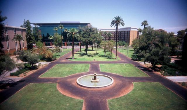
Palm Walk, Phoenix
The Palm Walk is a pedestrian mall located on Arizona State University's Tempe campus that is lined with one hundred and five Mexican fan palms. Running from the foot of the University bridge to the north, to the Student Recreation Complex to the south, the path runs for almost four-tenths of a mile. The path itself follows the old alignment of Normal Avenue, before it was incorporated into the expanding college's campus.
The history of the palm walk dates to an early attempt at campus beautification by Tempe Normal School President Arthur John Matthews. The best estimates for when the trees were planted vary from 1916 to 1919, although there also exist orders for trees in 1917 and 1918, the latter of which mentions the purchase of palm trees. Originally planted on the northern end of the walk near the original Normal School campus, the trees were later planted to the south, as the college expanded.
As the Palm Walk runs along the former alignment of Normal Avenue to what would have been the eastern edge of the main campus as it was built, it marked the eastern boundary for campus. As the college expanded over the years, it has become a local landmark for the university. The University Archives maintains a Web site that displays photos of Palm Walk from the 1930s, 1946, 1957, 1966, and the 1990s.
Originally, there was no official name for the Palm Walk, as a 1926 catalog for the school called it College Palms. By 1932, the name was simplified and called The Palms, and the earliest known use of the current name was from a 1967 pamphlet that used palm walk.
Sight description based on Wikipedia.
Want to visit this sight? Check out these Self-Guided Walking Tours in Phoenix. Alternatively, you can download the mobile app "GPSmyCity: Walks in 1K+ Cities" from Apple App Store or Google Play Store. The app turns your mobile device to a personal tour guide and it works offline, so no data plan is needed when traveling abroad.
Palm Walk on Map


Sight Name: Palm Walk
Sight Location: Phoenix, USA (See walking tours in Phoenix)
Sight Type: Park/Outdoor
Guide(s) Containing This Sight:
Sight Location: Phoenix, USA (See walking tours in Phoenix)
Sight Type: Park/Outdoor
Guide(s) Containing This Sight:
Walking Tours in Phoenix, Arizona
Create Your Own Walk in Phoenix
Creating your own self-guided walk in Phoenix is easy and fun. Choose the city attractions that you want to see and a walk route map will be created just for you. You can even set your hotel as the start point of the walk.
Downtown Historical Landmarks Walking Tour
The downtown area of Phoenix, Arizona, is loaded with notable sites, each bearing witness to a unique chapter in the city's past, from the Victorian elegance of the Rosson House Museum to the spiritual grandeur of Saint Mary's Basilica and the cinematic allure of the Barrister Building.
The latter, known as "The Psycho" Building, gained fame for its cameo in Alfred... view more
Tour Duration: 2 Hour(s)
Travel Distance: 3.9 Km or 2.4 Miles
The latter, known as "The Psycho" Building, gained fame for its cameo in Alfred... view more
Tour Duration: 2 Hour(s)
Travel Distance: 3.9 Km or 2.4 Miles
Phoenix Introduction Walking Tour
Phoenix is the largest city in Arizona and the central city in a larger metropolitan area known as the Valley of the Sun. The city was first settled as an agricultural community where the Salt and Gila Rivers met. An intricate canal system keeps this hot corner of the Sonoran Desert fertile. In the early days, the city's economy was based on the "Five Cs"—citrus, cotton, copper,... view more
Tour Duration: 2 Hour(s)
Travel Distance: 3.7 Km or 2.3 Miles
Tour Duration: 2 Hour(s)
Travel Distance: 3.7 Km or 2.3 Miles
Arizona State University (ASU) Walking Tour
Founded in 1885 by the 13th Arizona Territorial Legislature, Arizona State University (ASU) is one of the largest public universities by enrollment in the United States. ASU has nearly 150,000 students attending classes across its five campuses and four regional learning centers throughout the state.
The university's main campus at Tempe Arizona, east of downtown Phoenix, is an attraction... view more
Tour Duration: 2 Hour(s)
Travel Distance: 3.6 Km or 2.2 Miles
The university's main campus at Tempe Arizona, east of downtown Phoenix, is an attraction... view more
Tour Duration: 2 Hour(s)
Travel Distance: 3.6 Km or 2.2 Miles


