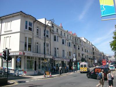
Queens Road, Brighton
Queen's Road in Brighton is a significant street redeveloped in 1845 as part of a slum clearance program to improve access between Brighton Railway Station and the town center. Before the street was constructed, the area housed 25 buildings, and part of the land had been used as a burial ground since the 1700s, associated with the Hanover Chapel. The development of Queen’s Road formed a new boundary for this burial ground.
The initial construction in 1845 was driven by the need to provide better connectivity from the newly established Brighton Station to key parts of the town. Queen's Road quickly became a bustling commercial thoroughfare lined with hotels, public houses, shops, and warehouses. Among the historic features are raised pavement and iron railings dating back to the early 19th century, which are now protected as Grade II listed structures.
In its early years, Queen's Road hosted several healthcare facilities, including a dental hospital located in a terrace house at No. 27, dating back to around 1830. Over the years, the road underwent several expansions. It was first widened in 1878, primarily at the cost of the railway company, and again in 1924 and 1935 through the demolition of several buildings, including the prominent Terminus Hotel, which had originally stood opposite Brighton Station.
One notable building along Queen’s Road is The Queen’s Head pub, which dates back to the late 19th century. Its heavily ornamented façade features French doors, a balcony, casement windows, and a parapet adorned with a bottle balustrade and decorative pediment. The north side of the pub was remodeled in the 1930s, and its detailing was later aligned with the design seen along Queen’s Road.
Want to visit this sight? Check out these Self-Guided Walking Tours in Brighton. Alternatively, you can download the mobile app "GPSmyCity: Walks in 1K+ Cities" from Apple App Store or Google Play Store. The app turns your mobile device to a personal tour guide and it works offline, so no data plan is needed when traveling abroad.
Queens Road on Map
Sight Name: Queens Road
Sight Location: Brighton, England (See walking tours in Brighton)
Sight Type: Shopping
Sight Location: Brighton, England (See walking tours in Brighton)
Sight Type: Shopping
Walking Tours in Brighton, England
Create Your Own Walk in Brighton
Creating your own self-guided walk in Brighton is easy and fun. Choose the city attractions that you want to see and a walk route map will be created just for you. You can even set your hotel as the start point of the walk.
Brighton Seafront Walking Tour
No trip to Brighton is complete without a stroll along the seaside. Here you will know right away that you’re in an English seaside resort, catching the scent of fish and chips and watching deckchairs fluttering in the breeze. Stretching along the pebbly coastline for nearly 5 miles, Brighton's promenade has that Victorian glamour with a dash of youthful energy and style, buzzing with life... view more
Tour Duration: 2 Hour(s)
Travel Distance: 2.0 Km or 1.2 Miles
Tour Duration: 2 Hour(s)
Travel Distance: 2.0 Km or 1.2 Miles
Brighton Introduction Walking Tour
The town of Bristelmestune is first mentioned in William the Conqueror's Domesday Book of 1085. In 1810 it officially became Brighton. The area of Brighton has known settlements since the Bronze Age. It experienced Celts, Saxons, Romans. But the train stopped with the arrival of the Normans in 1066.
When Conquering William took the helm, Bristelmestune was a fishing village of 400 souls.... view more
Tour Duration: 1 Hour(s)
Travel Distance: 2.2 Km or 1.4 Miles
When Conquering William took the helm, Bristelmestune was a fishing village of 400 souls.... view more
Tour Duration: 1 Hour(s)
Travel Distance: 2.2 Km or 1.4 Miles


