

Samphire Hoe, Dover
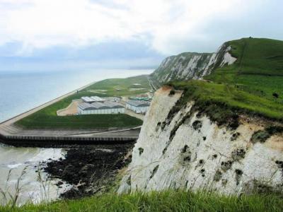
Samphire Hoe is a remarkable country park located 2 miles west of Dover in Kent, Southeast England. Situated at the base of the iconic White Cliffs of Dover, the park was constructed using 4.9 million cubic meters of chalk marl excavated during the creation of the Channel Tunnel. Samphire Hoe is a testament to innovative land reclamation and ecological preservation.
The park’s name, coined through a public competition, honors the rock samphire, a wild plant historically harvested from the cliffs. Combined with the term "hoe," meaning a landmass jutting into the sea, the name reflects its geographical and cultural roots.
Samphire Hoe is steeped in history. The cliffs above, known as Round Down Cliff, were dramatically altered in 1843 through gunpowder explosions to aid the construction of the Dover to Folkestone railway. In the late 19th century, the area saw unsuccessful attempts at both tunneling under the English Channel and coal mining. Evidence of these endeavors can still be seen, such as the remnants of Shakespeare Cliff Halt railway station platforms.
The park itself began to take shape in the 1980s when the site was selected as the most suitable of 60 proposed locations to deposit chalk from the Channel Tunnel excavations. Work commenced in 1988, culminating in the park's opening in 1997. Today, it also houses the cooling station for the Channel Tunnel on the English side.
Covering 30 hectares of reclaimed land, Samphire Hoe has become a haven for wildlife and outdoor enthusiasts. Its chalk meadow is home to rare plant species such as the early spider orchid and rock sea lavender, which blooms spectacularly in July. Birdwatchers can spot peregrine falcons, European stonechats, meadow pipits, and rock pipits, along with house martins nesting under the chalk cliffs.
Visitors can enjoy a 2-kilometer circular walking trail, with gradients designed for accessibility, and a seawall path made of smooth concrete. Activities include walking, cycling, angling on the sea wall, birdwatching, and participating in jogging events or fun runs.
Want to visit this sight? Check out these Self-Guided Walking Tours in Dover. Alternatively, you can download the mobile app "GPSmyCity: Walks in 1K+ Cities" from Apple App Store or Google Play Store. The app turns your mobile device to a personal tour guide and it works offline, so no data plan is needed when traveling abroad.
Download The GPSmyCity App
Samphire Hoe on Map
Sight Name: Samphire Hoe
Sight Location: Dover, England (See walking tours in Dover)
Sight Type: Park/Outdoor
Sight Location: Dover, England (See walking tours in Dover)
Sight Type: Park/Outdoor
Walking Tours in Dover, England

Create Your Own Walk in Dover
Creating your own self-guided walk in Dover is easy and fun. Choose the city attractions that you want to see and a walk route map will be created just for you. You can even set your hotel as the start point of the walk.

Western Heights Walking Tour
The Western Heights of Dover is an impressive fortification built for protection against invaders. Construction took place at the time of the Napoleonic Wars, with improvements continuing during the 19th century. This immense hilltop fortress features an incredible network of forts, barracks, tunnels, ramparts, and massive ditches.
There are two forts at Western Heights, the Drop Redoubt and... view more
Tour Duration: 1 Hour(s)
Travel Distance: 1.9 Km or 1.2 Miles
There are two forts at Western Heights, the Drop Redoubt and... view more
Tour Duration: 1 Hour(s)
Travel Distance: 1.9 Km or 1.2 Miles

Dover Introduction Walking Tour
The lovely coastal town of Dover in Kent, England, overlooking the English Channel from the height of the striking white chalk cliffs, has long been a major sea gate to the country. It is to this iconic landmark, known as the "White Cliffs of Dover", that the isle of Great Britain owes its nickname, the Albion.
According to archaeological findings, this location at the narrowest... view more
Tour Duration: 1 Hour(s)
Travel Distance: 2.8 Km or 1.7 Miles
According to archaeological findings, this location at the narrowest... view more
Tour Duration: 1 Hour(s)
Travel Distance: 2.8 Km or 1.7 Miles